
Baker Hill
Baker Hill was named after the Baker family who were descendants of Jacob and Anne Marie (nee Brecht) Baker, who settled in the area in

Baker Hill was named after the Baker family who were descendants of Jacob and Anne Marie (nee Brecht) Baker, who settled in the area in

Ballantrae was settled in the early 1800s and became a busy economic centre for the surrounding lumber trade. This community had several hotels, blacksmiths, general

The hamlet of Bethesda was clustered around the four corners of Warden Avenue and Bethesda Road. Bethesda was known for many outdoor religious camp meetings
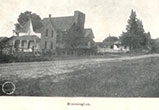
Bloomington, the community located at the intersection of Bloomington Road and Ninth Line, was named by Maxson Jones in 1869 after his hometown in Illinois.

Sawmills and gristmills were early industries for Cedar Valley, operating with power from Taylor Creek. The community, located at the intersection of Vivian Road and
A hillside church on the Hill family farm explains the origin of the name Churchill. William Hill came to the area around Ninth Line and

Gormley was named after James Gormley who ran a general store and post office at Stouffville Road and Woodbine Avenue. Gormley came to this area

This small German hamlet was once located at the intersection of McCowan (7th Line) and Stouffville Road. It was 1 ¼ miles west of Ringwood.

Primarily a farming community, Hartman was named after Joseph H. Hartman of Petchville, a well-respected figure in that community. Hartman, despite being the namesake, never
Located at Durham Regional Road 30 and Aurora Road is a kettle lake with an island, hence the name Island Lake. Farmers were attracted to

The Lemonville community, located south of Bloomington Road on McCowan Road, was named after George Lemon, who received his land grant here in 1805. A

Lincolnville was located at the corner of Bloomington Road and Highway 47 and was divided between Uxbridge and Whitchurch Townships. The tall pines in the

The community of Musselman’s Lake is named after the Musselman family who bought land surrounding the kettle lake in 1807. Peter and Jacob Musselman came

Pine Orchard, the community at Warden Avenue and Vivian Road, was settled in 1802 by Quaker families who emigrated from Pennsylvania. In 1814, the first

Known initially as Pleasant Valley, this hamlet was originally settled by Quaker families including the Widdifields, Tooles, Willsons, Lundys and Starrs. The property on the

Originally known as Reesor Lake and then Middleton Lake at the turn of the 20th century, the are was ultimately named after the Preston family

Ringwood was settled by the Fockler family in the late 1790s at the four corners of Markham Road and Stouffville Road. Nicknamed “Circle City” by
At McCowan Road, north of the Aurora Road, the road ends at a deep gully. This is the hamlet of Seldom Seen. It was not

The small hamlet of Shrubmount was settled at the intersection of Davis Drive and McCowan Road. Although the origin of the name is not known,
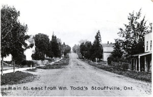
Initially a hamlet of Whitchurch Township, Stouffville got its name from Abraham Stauffer (Stouffer) who emigrated to the area in 1804. The community sprang up

Originally known as “Brookvale,” the community situated at Vandorf Sideroad and Woodbine Avenue had to be renamed in 1887 when the post office was opened

This hamlet was originally known as Sexsmith’s Corners after George Sexsmith, who operated a general store and inn. He was also the first postmaster. The

The community of Wesley Corners, located at the crossroads of Woodbine Avenue and Aurora Road, was originally called Hacking’s Corners after Rev. James Hacking, a